🌀 The Government Cuts Key Data Used in Hurricane Forecasting – Why It Matters More Than Ever
As the 2025 Atlantic hurricane season intensifies, a controversial decision by the U.S. government has sent shockwaves through the weather and climate science communities. In a move labeled by experts as reckless and deeply concerning, the government has officially cut off access to a crucial stream of satellite data long used in forecasting hurricanes — specifically, microwave data from Defense Meteorological Satellite Program (DMSP) satellites.
The abrupt halt of this data flow isn't just a bureaucratic tweak — it represents a fundamental blow to forecasting accuracy, emergency preparedness, and climate research. The timing could not be worse. With forecasts already projecting a more aggressive storm season due to warming ocean temperatures, experts say this decision may result in greater danger to life, property, and economic stability in coastal regions across the U.S.
🔍 What Is the Microwave Data, and Why Is It So Critical?
Unlike traditional satellite imagery that captures what storms look like on the outside, microwave sensors provide a unique view into the internal structure of tropical systems. This allows meteorologists to detect key features such as moisture content, rainfall distribution, and the development of inner eyewalls — signals that often precede rapid intensification, one of the most dangerous and difficult-to-predict phases of hurricane evolution.
Microwave satellite data has been instrumental in helping forecasters determine storm strength and potential track shifts, especially in nighttime hours or when cloud cover obstructs visual views. Without it, meteorologists are now relying on less frequent, lower-resolution, or less accurate alternatives. That’s a downgrade that some describe as both avoidable and potentially catastrophic.
🧠 Expert Reaction: “This Makes Us Blind at Night”
The response from the weather science community has been swift and sharp. Top hurricane forecasters and meteorologists warn that the loss of this data reduces our ability to accurately monitor storms during critical periods of their development — particularly during overnight hours when infrared and visible imagery fall short.
One leading meteorologist described the move as “removing the x-ray machine from a surgeon.” Another emphasized that forecast models may now underrepresent sudden shifts in storm strength, putting communities at greater risk for surprise wind intensification or storm surges.
Meteorologists say they now fear the rise of more so-called “sunrise surprises” — cases where a storm appears modest during the evening forecast but explodes in strength overnight due to undetected internal changes. These can result in delayed evacuation orders or insufficient preparation time, which historically lead to greater loss of life and damage.
🏛️ A Bureaucratic Shrug: No Clear Justification
Despite the intensity of expert backlash, no detailed explanation has been given by federal agencies. Officials from NOAA, the Department of Defense, and other involved institutions have called the shift a \routine data retirement.\ However, they have failed to provide technical or strategic justification for why a system so deeply integrated into hurricane forecasting was cut so suddenly, or why no replacement system was ready to fill the void.
The satellites in question were still operational, and the data they collected was being used not only for hurricane forecasting but also for broader climate monitoring, arctic ice tracking, and global rainfall estimation. Cutting it mid-season, without replacement, is what experts call a reckless gamble.
🌐 Bigger Picture: A Pattern of Climate Data Cuts
This is not an isolated incident. In recent years, the U.S. federal government has scaled back investments in climate observation infrastructure, citing budget constraints and \streamlining\ mandates. These include:
- Closure or defunding of climate-focused satellite programs.
- Reductions in NOAA staff and field offices.
- Canceled balloon launches essential for capturing upper-atmosphere data.
- Trimming of federal weather station maintenance budgets.
These measures collectively weaken the nation’s forecasting capacity, particularly as climate-driven weather extremes become more intense and frequent.
🌊 What This Means for Coastal Communities
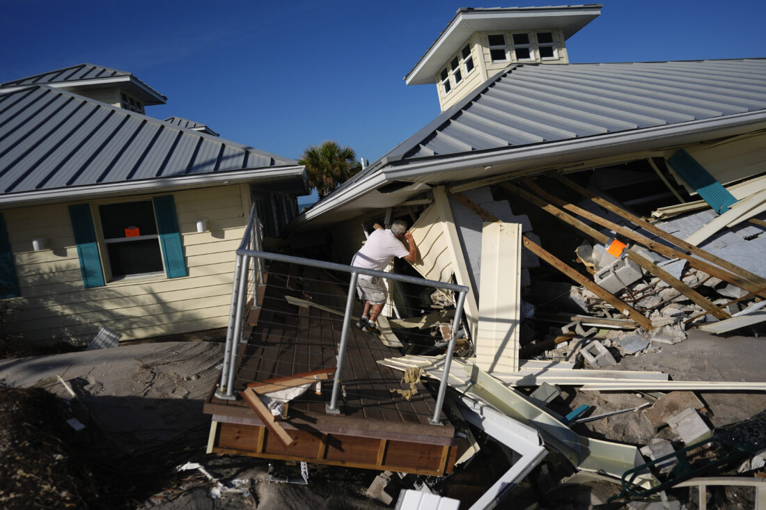
The states most impacted by Atlantic hurricanes — such as Florida, Louisiana, North Carolina, and Texas — rely heavily on accurate and timely data to prepare for storms. Emergency management agencies, hospital networks, power utilities, and local governments use forecasts to make life-and-death decisions.
With the absence of microwave data, experts caution that forecast confidence will decline, meaning:
- Longer delays before official warnings are issued.
- Lower confidence in storm strength and projected track.
- Higher risk of missed evacuations or late preparations.
- More economic losses due to miscalculated storm impacts.
Even sectors like agriculture, insurance, and tourism could feel the effects of a downgraded forecasting system — a ripple effect that stretches well beyond meteorology.
🧪 Is There a Replacement?
According to NOAA, newer satellites equipped with updated sensors like the Weather System Follow-on Microwave (WSF-M) will eventually help fill the gap. But those systems are not yet operational, and experts argue they were never meant to fully replace the lost DMSP capabilities.
Some foreign satellites offer partial coverage, but access is inconsistent and dependent on international agreements. Meanwhile, private-sector weather companies, though growing in capability, still rely heavily on public data as the foundation of their models. In short, no solution is currently in place to match the breadth and reliability of the discontinued data.
⚠️ Long-Term Impact: Weaker Warnings, Bigger Disasters
Over the past few decades, improved forecasting tools have helped dramatically reduce the death toll from hurricanes in the U.S., even as storms themselves have grown stronger. One of the main reasons? Better satellite surveillance, particularly during storm formation and intensification.
By removing key data, the country now risks sliding backward in storm preparedness. While cities have improved their infrastructure, evacuation procedures, and emergency alert systems, those systems only work if accurate data informs the decisions behind them.
Some experts fear that if this decision is not reversed or offset soon, lives could be lost unnecessarily, not from the storm itself, but from the failure to detect its real strength or direction in time.
🧩 The Broader Message: Why Weather Data Is a National Asset
This development shines a spotlight on the importance of viewing weather data as a national strategic asset — one that must be protected, funded, and continuously upgraded.
Cutting costs in the short term may appear efficient on paper, but in practice, it weakens public safety, national defense (which also relies on weather models), economic resilience, and climate adaptation planning.
Forecasting is not just science — it’s a lifeline. The technology that powers it must be treated with the same seriousness as any other public infrastructure. Roads, bridges, and communication towers matter — but so do satellites, sensors, and the invisible data highways that let us see the future coming.
📝 Key Points for Your Readers
This issue deserves clear framing for a general audience. Here are key takeaways you can use in summaries, newsletters, or social captions:
The U.S. government has cut off a major source of hurricane tracking data from operational satellites.
Experts warn this will weaken the accuracy of storm forecasts, particularly for rapidly intensifying systems.
There is no complete replacement yet, meaning gaps will exist during the 2025 hurricane season.
The decision reflects a broader pattern of cuts to climate and weather observation capacity.
These reductions could result in delayed warnings, missed evacuations, and greater human and economic losses.
🗣 Final Thoughts: When Data Goes Dark, So Do Warnings
Hurricanes don’t wait for budgets or bureaucracy. They form, strengthen, and make landfall with force and unpredictability. Our ability to prepare for them depends on what we can see — and the U.S. government has just chosen to close its eyes to one of the most crucial views available.
Microwave satellite data is not just for scientists in lab coats — it’s for families planning evacuations, hospitals coordinating emergency responses, and governments trying to protect the public. To remove this tool without replacement, at the height of hurricane season, is not just a technical failure. It’s a failure of priorities.
If this data loss is allowed to stand, the 2025 hurricane season may be remembered not only for the storms it brings but for how unprepared we were to face them — not because we lacked the science, but because we chose not to use it.
.webp)


Comments 0